|
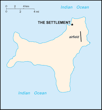
It is an Australian external territory comprising the island of the same name. It is located in the Indian Ocean, around 350 kilometres (220 mi) south of Java and Sumatra and around 1,550 km (960 mi) north-west of the closest point on the Australian mainland. It lies 2,600 km (1,600 mi) northwest of Perth and 1,327 km (825 mi) south of Singapore. The majority living in settlements on the northern edge of the island. The main settlement is Flying Fish Cove
|

|
|
|
Economy:
Phosphate mining had been the only significant economic activity, but in December 1987 the Australian government closed the mine. In 1991, the mine was reopened by Phosphate Resources Limited, a consortium that included many of the former mine workers as shareholders and is the largest contributor to the Christmas Island economy. With the support of the government, the $34 million Christmas Island Casino and Resort opened in 1993 but was closed in 1998
|
|
.jpg)
|
|

.png)

.jpg)

